


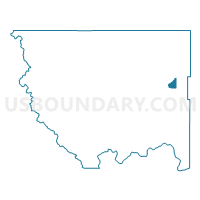
Cape Labelle Voting District, Okanogan County, Washington
About
Outline

Summary
| Unique Area Identifier | 687653 |
| Name | Cape Labelle Voting District |
| County | Okanogan County |
| State | Washington |
| Area (square miles) | 12.54 |
| Land Area (square miles) | 12.53 |
| Water Area (square miles) | 0.01 |
| % of Land Area | 99.96 |
| % of Water Area | 0.04 |
| Latitude of the Internal Point | 48.59130000 |
| Longtitude of the Internal Point | -119.04653250 |
Maps


Graphs
Select a template below for downloading or customizing gragh for Cape Labelle Voting District, Okanogan County, Washington


Neighbors
Neighoring Voting District (by Name) Neighboring Voting District on the Map
- Aeneas Voting District, Okanogan County, WA
- San Poil Voting District, Okanogan County, WA
- Sourdough Voting District, Okanogan County, WA